The Anti-Atlas or Little Atlas is the southernmost range of the mighty Atlas Mountains. It stretches from the Atlantic Ocean approximately 500 kilometers northeastwards between the High Atlas and the Sahara desert. The Anti-Atlas is a traditional region of the Berber people with various dialects and a totally different writing which reminded us a little bit on Greek characters. Mainly they live in oasis in the extreme dry desert climate with huge differences between the settlements. Famous are its castles - Kasbah and fortified granary citadels - Agadir.

From our westernmost point on this trip to Morocco - Sidi Ifni on the Atlantic coast we came directly to our southernmost - busy Guelmim which is called the door to the Sahara desert. Its is an old medium sized city with approximately 200,000 people where in former times the camel caravans from Mauritania, Senegal and other sub Sahara areas ended, and traded their goods.

Few kilometers northeast of Guelmim we experienced an awful sandstorm with nearly no visibility. Fortunately we found a decent camping place in Bouizakarne, soon.

The small village of Amtoudi on the southern slopes of the Anti-Atlas is an oasis like in a dream - incredible greenery in the gray-brown desert, located in a deep gorge, accompanied by two fortified granary citadels - Agadir Id Aissa and Agadir Aguellouy on top of its slopes and not too much tourism. We explored Amtoudi and its surroundings for four days, including hiking into the dry plains south and north above the gorge.


Bustling Tafraout is the main settlement of the Anti-Atlas. Due to its proximity to Agadir, it is visited by tourists much more often than Amtoudi. However, it is set in a breathtaking environment with spiky mountains and strange rocks where gravity seems to be lost. We found a cozy campsite that was almost as beautiful as it was in 1986 with our two and a half year old daughter Eva and Marion's brother Tommy. Tafraout was a trip down memory lane for us because we have many fond memories of it.


In 1986 we had hiked up 2344 meters high mountain Adrar Mkorn where we had seen some blue dots in the landscape below us. Of course we had to investigate this strange place and it had turned out that the Belgian artist Jean Vérame had colorfully painted some rocks in the year 1984. Nowadays these blue rocks are one of Tafraout's main attractions and have often been expanded and renovated by locals.


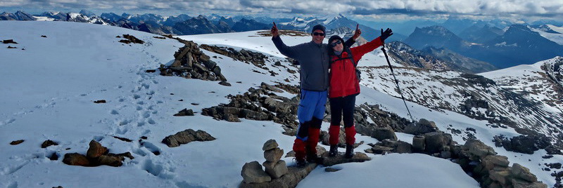
From Tafraout we continued few kilometers northward to Ammelne because Alfred wanted to climb up Jebel L'Kest which is the major peak in this area. A very narrow and winding road takes you to the mountain village of Tagdicht, where the strenuous 4-hour hike to the summit begins. We didn't dare to drive to Tagdicht with our campers, but Hermann lent Alfred his e-bike. Marion accompanied Alfred early in the morning, but she spend a nice day in Tagdicht.
The ascent to the 2359 meters high summit was stunning in a pristine, sometimes green and lush environment with very few people.


From Ammelne we traveled on very good roads towards Marrakesh with stops in Tawriyrt Lyyirgh, Tizourgane, Ait Baha and Biougra before we came to the might High Atlas - that's the next article.


For more pictures, please click here
For a map of our itineraries, click here
.