The 2nd largest state of the United States Texas is not famous for mountains but for its oil, cattle, prairies, pastures, deserts, nice beaches, heat and huge cities like Dallas or Houston. In is southwest corner we found some interesting peaks in the two National Parks Big Bend and Guadalupe.
On March 9th 2017 we crossed the border from Mexico to the busy town Del Rio without any issues. Our first stop was the supermarket Walmart because we were curious about fresh food which we could not take over the border. Jesus, the prices for food were shockingly high in comparison to Mexico or Germany. In the afternoon we hiked the Sunrise Trail from the Visitor Center of the Amistad National Recreation Area. The views to the Amistad Reservoir were excellent.

We spent our first night in the United States for little money on the remote campground Amistad 277 North (GPS coordinates: N29° 30.650' W100° 54.424'). Our trail is included in our GPS coordinates file of Texas.
Approximately 50 kilometers northwest of Del Rio is the beautiful Seminole Canyon where we hiked along the rim of the canyon up to the mouth of the Seminole river into majestic Rio Grande.


The top highlight of the Seminole Canyon is the Panther Cave at the end of the gorge. It is a rock shelter used by the Desert Archaic Culture about 9,000 to 1,300 years ago. There are nice old wall paintings on its back wall. It is forbidden to visit this cave without a guide but we could see the red Panther with our binoculars.


We hiked more than 15 kilometers and we were a little bit tired when we came back to our car. There is a campsite in the Seminole Canyon State Park but it is relatively expensive. Thus we decided to continue to the Langtry Community Center with a free campsite (GPS coordinates: N29° 48.558' W101° 33.529'). Striking was an orange motor-home on the campsite in the Seminole State Park but we did not check its plate.
When we fuelled our car in the little town Sanderson the little orange camper came. Surprisingly it has a south German plate and we were warmly welcomed by Ilse and Elmar. We were so happy meeting Germans because the last ones had been mid of January! We four realized that we had the same direction, the Big Bend National Park.
Due to the Spring Break in Texas all campsites of Big Bend were fully occupied. Thus we stayed on the side street RM2627 few kilometers outside of the park (eastern entrance). On the next morning we visited the interesting Fossil Discovery Exhibit and hiked to the Balanced Rock, which is a landmark of Big Bend. The continuation to the Grapevine Hill was somehow complicated because we had to scramble a little bit and there were many spiky cactuses on the way.


Again we could not camp in the park and we left is via its western entrance. Opposite of the gas station of Study Butte we found a picnic place in the roundabout Highway 118 / FM170 (GPS coordinates: N29° 19.748' W103° 32.103'). Staying the night on a picnic place is permitted in Texas. After a splendid dinner we spent a quiet night despite the roundabout.
Santa Elena Canyon in the western part of Big Bend was our next destination. Again all campsite were busy on the following day and consequently we had to return to the roundabout in Study Butte.


After dinner with some heavy stuff we said sadly goodby to Ilse and Elmar. We had a lot of fun together - thank you so much Ilse and Elmar.
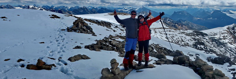
The wake-up call on the next morning at 4:00AM was brutal but we wanted to climb up Emory Peak which is the tallest mountain of Big Bend. We drove one hour to Chisos Basin and started the hike at total darkness. Suddenly a strange sound appeared - maybe a Black Bear?! We continued slowly and warily with a weird feeling in our stomach. Suddenly a girl was in front of us and she asked us if she could join us. We were more than happy to be with Sarah and we achieved the summit together. The last part was a little bit challenging due to some easy rock climbing.

Our track is included in the GPS coodinates file of Texas. Sarah invited us to her campsite in the Chisos Basin and we were happy that we could sleep early - Thank you so much Sarah.
Boquillas Canyon is on the eastern side of Big Bend. Alfred dared to swim in Rio Grande which was a pleasant experience in the heat. On the US shore were Mexican men offering stuff for tourists. They sold a lot despite the warning signs that selling from Mexicans is illegal and will be fined. At dawn the Mexican men collected their stuff and they crossed Rio Grande and the border with their horses without any problems.

West of Big Bend National park is Big Bend Ranch State Park where we did some smaller hikes. Outstanding is the Closed Canyon Trail.


The highest mountains in Texas are in the nice Guadalupe National Park. We drove with a stop in beautiful Marfa but we did not see its famous lights. Few kilometers west on the US90 is a good picnic place where we spent the night (GPS coordinates: N30° 19.199' W104° 05.169').
This time we were lucky with camping in the Guadalupe National Park and we could use its facilities. There we met Doro and Peter from Berlin. We spent two nice evenings together and they know the United States very well and they gave us many valuable hints - Thank you so much Doro and Peter.
Our alarm-clock rang two times at 4:30AM. We wanted to start our hikes very early because it became very hot at noon. Firstly we climbed up Guadalupe Peak which is the highest point of Texas (2657 meters sea-level). On the next day we did the round trip Bear Canyon - Bowl - Hunter Peak (2550 meters sea-level) - Tejas. Both were superb hikes with outstanding views into the desert. Our tracks are included in the GPS coordinates file of Texas.


For more pictures, please click here For a map of our itineraries, click here
To download our GPS coordinates file of Texas click here